The plan for this trek was to camp near Courtright Reservoir and paddle our kayak on the beautiful lake. We made camp at our usual spot near Glen Meadow. This was our third trip to Courtright and each time we run out of daylight and camp short of our destination in the same location.
Dawn in the Sierra National Forest.
There was a noise in the bushes near some trees about 75 feet away.
I wish Jan would let me know what direction she was going when she was going to go.
Headed back to pavement.
We drove across Courtright Dam.
On the other side of the dam we positioned the truck for a photo.
The beginning of the Dusy-Ershim Trail and the road to Voyager Rock Campground. It is rated difficult from here to the campground and most difficult for the rest of it's 31 miles.
First granite section.
Following the JEEP signs through the forest. When driving this trail with a camper it pays to keep an eye on the the angle of the trees above your rig and the potential slide/rocking of your vehicle when climbing over the rocks. Several times after looking in the mirrors to check our position I had to back up and try a different line. Once we came very, very close to calamity. The photo above does not represent how close the trees get to the trail but the wounds on the trees will let you know when danger is near.
When I commented to Jan that the trail was much more difficult than I remembered, she reminded me that the last time on this trail in 2001 we were driving my Unimog.
On that trip I don't think we engaged the 4WD until the rock garden just before Chicken Rock. The trail did not seem so easy in a Tacoma with a FWC in the bed.
On the granite with Maxson Dome in the distance
Looking back.
Jan spotted a marmot near the trail.
Arriving at our destination.
We set up camp about 100 feet from the shoreline. The only other people at Voyager were a family from Fresno who were camped a few campsites from ours.
Each morning we paddled our Sea Eagle 370 kayak to a nearby island and ate breakfast.
In the early morning the waters of the lake were smooth and clear. That would change after 10 A.M. when the wind would churn the lake until 7 P.M.
Every evening we paddled the lake again. Jan and I couldn't decide which time of day was we enjoyed more, morning or evening.
After a few days our camp became very comfortable. The solar panel maintained a good charge in the camper battery even with the new WAECO Compressor Refrigerator/Freezer running all day. At night the lows were in the 30's, ironically we turned the refrigerator off and the furnace on.
After four days on the lake it was time to return home.
Nearing the end of the trail. After driving the most challenging section of this trail we drove by four people standing around a 4x4 pickup parked off the trail. As we passed by I heard one of them say, "hey, we can make it through that stuff, they made it with a camper."
Pavement only 30 feet away. Once there we will no longer worry about the camper hitting a tree.
Our neighbors at Voyager Rock Campground. Andy, Tracy and their son Dylan from Fresno. Theirs was an excellent strategy for camping at Voyager. Put boat in water, have son pilot boat across lake, drive truck to campground and avoid the crowds camping near the dam.
While driving out from Courtright we stopped and made lunch at the McKinley Grove of Giant Sequoias.
Jan on the left looking up.
Ugly damage and repair alert. The following photos contain an ugly repair to a very nasty looking bit of frame damage.
On our drive north to Fresno on US 99 we crossed a couple of bridges that caused the truck to bounce high and come pounding down. After the second event I glanced in the rear view mirror and it looked like the camper was riding oddly but when we pulled over to check it out everything seemed normal. We drove on to our first night camp which was just a short 4x4 drive from pavement. Once again the camper and bed seemed to be riding oddly. Jan drove the the truck around while I watched and the bed and camper were indeed moving oddly. Once again I checked the airbags, the springs and the reinforced frame over axles, everything was okay. Then I examined the frame in front of the reinforcement and discovered the problem.
More of a problem than I expected to find. It all made me wonder how long the frame had been cracked before the damage on US 99.
My father when he wasn't working at the steel mill ran a repair shop for vehicles and farm equipment at his home outside the city. One of the many proverbs he would quote to customers came to my memory
when looking at the crack. When asked to weld a strong reinforcing patch to fix a piece of equipment he would say, "If we reinforce it here, the next time it
will break at the next weakest place." He was correct then and now.
After reinforcing the frame over the axles, this location became the
next weakest place. Should have reinforced the entire frame.

After surveying the damage, another thought came to mind: How were we going to fix this problem with the tools on hand? Night fell and I tried to go to sleep but my mind wouldn't stop trying to solve the problem. Around 2 A.M. I said a prayer asking God to help me come up with a solution. About 30 minutes later I had an idea and was outside the camper in the dark with my headlamp looking for parts to build the patch. When I found the angle iron and four bolts sleep came easy.
The next morning we took a piece of slotted angle iron that I had bolted on the winch to hold tire chains in winter and pounded it flat on a granite slab.
Then we cut off two pieces and doubled them up. Drilled four holes and bolted the patch on the frame. We were lucky the cordless drill was with us because I planned to drill holes in some PVC pipe to make a sail for our kayak. Another stroke of luck was that the crack was located in a place that was easy to repair.
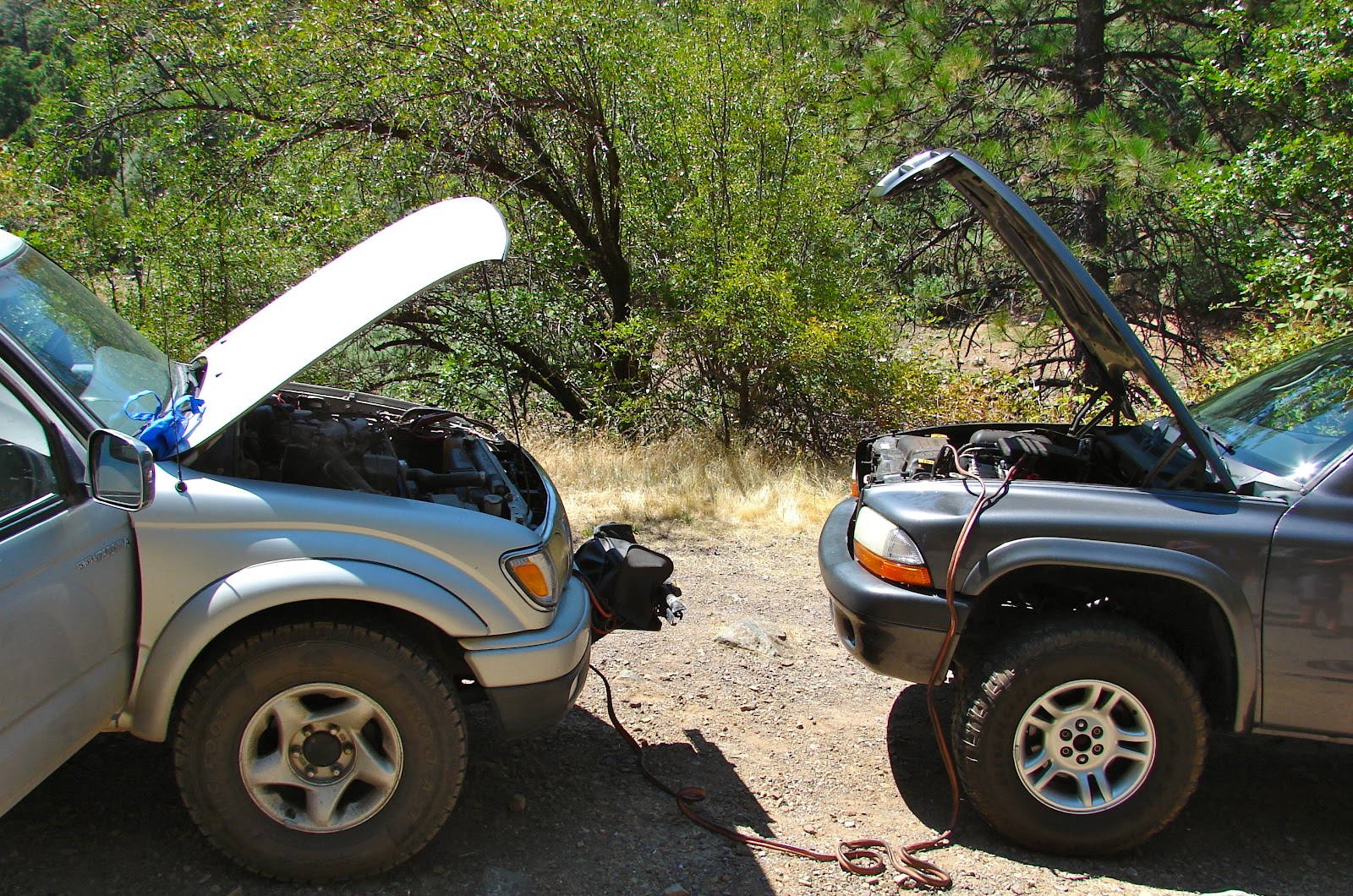
The final piece of luck occurred on our last evening at Voyager Rock camp. Our neighbors Andy and Tracy walked over to check out the FWC. They also owned a Tacoma but were tent camping. While we were talking I explained to Andy about the problems of mounting an Eagle on a short bed Quad Cab Tacoma like the two of us owned. He looked under the truck and noticed the patch. I told him what had happened, he told me that he was a welder by trade and offered to weld the crack closed at his shop. They were leaving the same day as we were. What were the odds?
A day later we were driving down Kearney Avenue headed to Andy's welder.
After Andy's repair we would not have to worry about our patch failing on the drive home. When I made that comment to Jan while driving south from Fresno she said, "you were confident enough in the patch to drive that rough 4x4 trail into Voyager Rock Campground." I replied with a sheepish grin, "the trail was harder than I remembered."