We drove west across the Lockwood Valley to CA 33.
After driving north for a few miles we turned left and drove west toward the Rancho Nuevo trailhead
Cuyama Wash.
Fording the mighty Cuyama River. No disrespect intended because in the past near this location I have observed the river to be a raging, very scary body of water 60 yards wide.
Turning south into Rancho Nuevo Canyon.
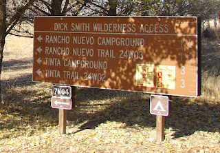
Approaching the trailhead.
At the trailhead our hike began with a little sadness after reading the note below.
Entering the wilderness.
The trail was in very good shape.
Many trees had survived the Zaca Fire in 2007.
As we approached Deal Junction a helicopter flew over the canyon.
Clark and Jo Ann at Deal Junction Camp. Not much of a camp but hard to miss.
Looking west into Upper Nuevo Canyon. The rest of the trail will have to wait until another time.
Baby Elephant Rock?
Both of my hiking companions photographed a tree. It was a very colorful tree and after they were finished I took a photo.
Many curious formations along the trail.
Everyone seemed to be hiking faster than me.
We sighted a cave about 150 feet above the trail but none of us had the gumption to climb up to it.
Fall colors were in view all along the creek bottom.
The single tree at the top of this formation just cried out to have it's photograph taken. After noticing the first cave above the trail we began to look for others. We sighted several others and wondered how many caves there were in the area that might be filled with Native American artifacts like Bowers Cave.
On the drive up the weathered road we spotted a short road leading to a small clearing that would make a great camp.
Jo Ann climbed up on their camper to make a small repair. While up there she remarked that the view was excellent.
Sunset at our camp high on the western ridge of Pine Mountain.
Cuyama Valley to the north.
We set up our chairs and ate dinner as the sky began to darken.
Dawn. The sun is just beginning to shine on Cuyama Peak to the north.
Far in the distance Caliente Peak 'peeks' over Cuyama's shoulder. Drove to the top of Cuyama back in 2004 and examined the old lookout. Hiked/biked to Caliente's summit in 2010.
Clark, when walking around just after dawn, picked up the sign to examine it and discovered our transgression.
The Pine Mountain road alternates between being comfortably paved and jarringly rutted. More rutted than paved.
We turned onto Camp Scheideck Road to scout the Piedra Blanca trailhead.
If the reader is ever driving the Lockwood Valley Road, Camp Scheideck is worth a visit. My first stop at this hidden village was in 1988.
My friends and I had lunch at the Reyes Creek Bar and Grill. The next visit was in 1994 while camping at Reyes Creek Campground.
The Piedra Blanca trailhead was scouted for a future hike. After meeting Clark and Jo Ann back at Camp Scheideck, we returned to the Lockwood Valley Road and continued east to Interstate 5, where they drove north and I south.


