Use the archive on the right to view older posts.

Saturday, July 19, 2014

Eshom Valley - Sequoia NF - "Seriously out of the way campground"

 After leaving our Park Ridge camp we drove over to the Buck Rock Lookout.
 The stairways at Buck Rock were wooden instead of steel.
 While talking with the lookout observer I heard voices on the stairs. I looked down and there were Jeremy and Micah, who had visited our camp on Park Ridge the day before, climbing up to the lookout.
 Rain clouds south of Buck Rock reminded us that we had a couple of friends to visit before dark.
 After dinner with friends at Hume Lake we drove southwest through the forest to the small village of Badger.
 Then headed east toward Eshom Campground.
The sign in the photo above reminded me of a story I read once in an old newspaper. The entire story here.
 We arrived at Eshom Campground and were greeted by some very surprised friends.
 Shelia gave us directions and dates for their camp about six weeks earlier but I told her that the chances were slim that we would join them. But we knew what she did not, that we were planning on visiting the western Sierra during the same week. All three were very surprised when we pulled up to their seriously out of the way campground just before sunset.
Our morning began with the sound of thunder and a brief rain shower.
Later in the morning I noticed that there were gooseberries growing around the campground.
Evidence of some misjudgement during a tree felling.
  After breakfast we said goodbye to Richard, his daughter Shelia and her friend Verina.
A road across the Sierra Foothills to US 99 and home.

Friday, July 18, 2014

Park Ridge - Sequoia NF - "Instead we found bear tracks"

 We crossed CA 180 at Cherry Gap and drove up to the Park Ridge 4x4 road.
 We turned left heading north looking for a place to camp.
 But instead we found bear tracks.
 A small black bear had crossed the road. Maybe it would stop by our camp later for a game camera photograph.
 There were a couple of rocky sections on the road and I was trying to make this one look as difficult as possible. (wink)
 After a couple of miles driving north and not finding a good campsite we reversed direction and returned to the junction. In less than a mile of driving south we found a great campsite overlooking Hume Lake.
Hume Lake below our campsite.
Later in the afternoon the buildup over the eastern Sierra increased. Jan and I remembered the thunderstorms from last year's trip and longed for some rain.
 Dawn. Our first night at the new camp was uneventful. No visit from the bear whose tracks we had found on the road.
 After breakfast this squirrel was giving me a hard stare. Maybe trying to induce me to toss it another peanut.
 Buck Rock Lookout to the southeast.
 We both spent the day reading and relaxing. While reading "Early Days in the Range of Light: Encounters with Legendary Mountaineers" by Daniel Arnold I suddenly realized that at our location some of the mountains mentioned in the book would be visible.
I soon spotted Mount Clarence King to the east.
 Our camp later in the afternoon and not the best orientation for the solar panels. The array only received full sun for about three hours.
 Around dusk Jeremy and his son Micah stopped by to talk about 4x4 roads in the area.
Later that night I attempted a Milky Way photograph but found there were still a few clouds in the sky.
 Another sunrise at our Park Ridge camp and soon it would be time for us to move on.

Wednesday, July 16, 2014

Converse Grove - Sequoia NF - "Happy to have a rip saw"

 After visiting a friend in Fowler we drove east into the Sequoia National Forest.
 When studying a map of the area I noticed that the forest service allowed dispersed camping in the Converse Grove. It looked like a good place to go for some peace, quiet and cool.
 The road was an easy drive to this junction. But we engaged the 4WD just 50 yards into the road on the left. Nothing serious but enough to warrant the sign in the photo.
 My passenger opened and closed several gates because there were bovine grazing in the area.
 Sometimes the road wasn't much more than a quad track.
 Jan inspecting an old Sequoia stump. Just after this stump the road crossed a small marsh that still had a little water flowing.
 There was plenty of evidence that this was quad territory. We started to encounter tree fall tunnels that were barely passable. "It's good to own a pop-up camper," was voiced by the two of us several times on this route.
 One tree fall was blocking our route and had to be removed. Once again we were happy have carry a rip saw in our gear. Stump on left.
We set up camp just after sunset at the only clearing we could find. This 20 second exposure captured the silhouette of a young Sequoia, a timeless great bear and a 2006 Four Wheel Camper.
 Our camp in the morning light. Both Jan and I commented that this had been a very quiet place to camp.
Quiet until a helicopter flew over later in the morning.
 Our camp was surrounded by some gorgeous trees.
 Standing high above our camp.
We left our campsite around noon and drove to Stump Meadow. On a walk around this little meadow we counted 15 gigantic Sequoia stumps.
On our return to pavement we drove past the Chicago Stump trailhead. But both Jan and I thought that we had seen enough Sequoia stumps.

Sunday, July 13, 2014

Big Sur - Willow Creek/Los Burros Road - "Ghostly woman following"

 After returning to the Pacific Coast Highway we drove north past Lucia looking for something I remembered from a motorcycle ride 30 years ago.
 Stopped here in 1982 while riding the PCH to Oregon. It certainly has changed, I believe the fountain was working back then. I do remember having a nap here. This abandoned little park was once an important feature on this highway. "The Fountain was dedicated to Hon. Elmer S. Rigdon of Cambria, California, Born 1868, Died 1922. His foresight and efforts made possible the Carmel-San Simeon-Cambria link of the Roosevelt Highway. A token of esteem from his San Luis Obispo County Friends” - http://cambriahistory.org
 After visiting the Rigdon Fountain we reversed our course and drove south looking for a place to stop for lunch. Eagle-eye Jan said she saw whales off the coast.
 How she saw the whales is beyond me because they were barely visible at 40x zoom.
 We stopped for lunch at the Mill Creek Picnic Area and there were PUBLIC RESTROOMS, which are very rare along the Big Sur Coast.
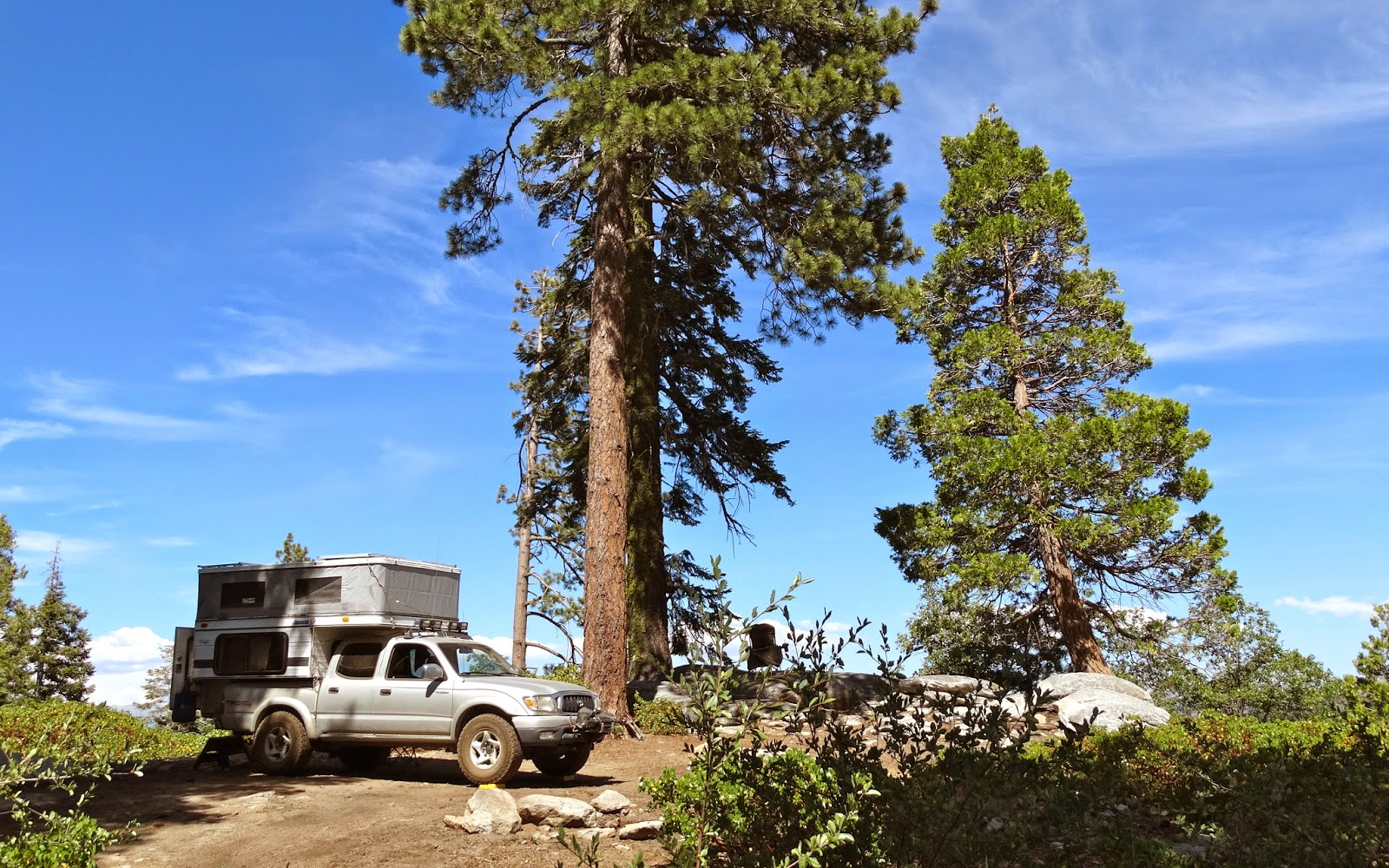
Our plan was to find a campsite higher than the day before on the less traveled Willow Creek Road.
 We found several campsites early on in our drive but the elevation wasn't high enough and none had a view of the ocean.
A few miles in we found a nice spot with level ground at 1100 feet.
We spent the rest of the day reading and savoring the view.
 The next morning after reviewing the photos from the game camera I asked Jan, "What was the name of your friend following you back to the camper late last night." It only took her a few seconds to see the head and shoulders of the ghostly woman following behind at her knees.
 Sunrise above Willow Creek.
 Los Burros Road on the left and the PCH bridge over Willow Creek lower center.
Later in the morning we heard the sound of multiple engines bouncing between the ocean and the mountains.
Soon a Coast Guard HC-130 appeared below us roaring up the coast above the ocean and under the fog.
After a leisurely breakfast it was time for us pack up our camp and drive down the canyon.
It was a very scenic departure.
Cape San Martin and Highway 1, our road home.