A traffic jam in Barstow at 3:30PM on a Monday. Who would have thought?
Two hours later the sun was setting.
We stopped at the Mountain Springs Road exit for Bosco to stretch his legs.
After purchasing fuel in Needles we drove South and then West on the Heart of the Mojave road.
Our camp at the edge of the wilderness boundary.
The dawn sky was cloudy.
The trail behind this sign follows an old road for a portion of the route to Mopah Spring. I had intended to hike the four miles to the spring but an old injury flared up and cancelled that plan because I wanted to save the miles for another hike.
We spent a leisurely morning relaxing at the trail-head before driving on to our next destination.
After 30 minutes we returned to pavement.
Then we drove a few miles North and turned West onto another dirt road.
Umpah and Mopah in the distance behind abandoned mining equipment.
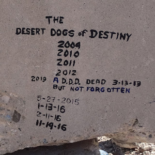
We drove over and found
an interesting
monument.
And then it was back on the old road that seemed to get sketchier by the mile.
We stopped and set up camp after the road conditions deteriorated to the point where is was faster to hike than drive.
Bosco and I left our camp behind and hiked West toward the objective.
Umpah and Mopah were a constant presence to the Southwest.
After two miles the remains of a cabin came into view.
The cabin was in bad shape and no longer habitable.
But this note scratched on a wall panel saved us a hike up to the mine. Thank you, MW.
Bosco posed for a photo as I consulted a map to check on our route.
We hiked on and dropped into a wash.
Debris tangled in the trees showed that some deep water had flowed down this wash.
The sun was setting when we turned back.
One last look to the South before darkness descended.
The last mile of our hike was in the moonless night and it was good to see the porch light of the camper ahead in the darkness.
Bosco and I were up early to watch the sun rise.
Umpah and Mopah in the distance behind our camp.
The road back to pavement seemed shorter but just as rutted.
We drove South to Vidal Junction and then turned East toward Parker for lunch and fuel.


